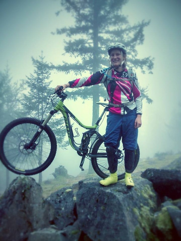
I grew up riding in Gold River and started when I was about 14 years old. My dad liked to go ride around a place called Antler Lake, which has a little cross-country biking/hiking trail around it. Not too long after riding with my dad I started getting pretty serious and riding with other people around town. I had a Norco Sasquatch with Super T's and then a Norco Shore with monster T's... How did I ever get anywhere with those heavy bikes? I was mainly into drops and jumps.
Back when I was growing up the trail network in Gold River was phenomenal and there were a lot of people invested in trail maintenance. These days things are looking a little over grown... But there once were some great jumps, structures, berms, rock rolls, etc all around the Scout Lake and Antler Lake area.
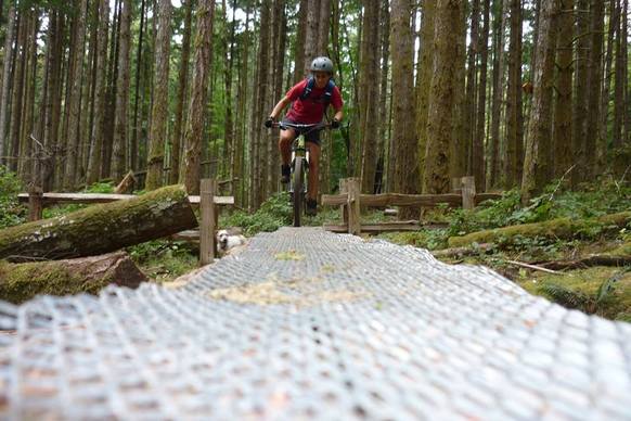
In the last few years Darryl and I have been making a serious effort to check out new places on the island to mountain bike. Listed below are a few spots we have been to fairly recently. We have also ridden Snowden (Campbell River), Cumberland, Tzuhalem (Duncan), Dumont (Nanaimo), and the Hammerfest trails (Errington).
Maple Mountain
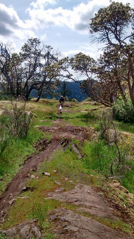
I have been hearing from rider after rider that the trail "Maple Syrup" on Maple Mountain is a must for any mountain biker on Vancouver Island. Thus, Darryl and I made some time to hit up this area a couple times in the past year. To get to the trail head drive from Victoria just barely north of Duncan, take a right on Herd Rd, and a left on Osbourne Bay Rd. Park off to the righthand side of the road in a small gravel pull off at the gated Maple Mountain Park Rd. Impossible to miss, there are usually other vehicles parked here.
To get to the top we basically just stuck on the main logging road all the way to the very end where there is some kind of a building and cell tower. It generally takes us 45-50mins and is fairly steep at some points. Enough to get the lungs going pretty good. At the top there is a nice sign for the trail as seen below off to the right side of the fenced building. Pretty simple to follow after that. There is a new up-trail that we have yet to try. The last time we were there I had no idea it even existed.
Back when I was growing up the trail network in Gold River was phenomenal and there were a lot of people invested in trail maintenance. These days things are looking a little over grown... But there once were some great jumps, structures, berms, rock rolls, etc all around the Scout Lake and Antler Lake area.
In the last few years Darryl and I have been making a serious effort to check out new places on the island to mountain bike. Listed below are a few spots we have been to fairly recently. We have also ridden Snowden (Campbell River), Cumberland, Tzuhalem (Duncan), Dumont (Nanaimo), and the Hammerfest trails (Errington).
Maple Mountain
I have been hearing from rider after rider that the trail "Maple Syrup" on Maple Mountain is a must for any mountain biker on Vancouver Island. Thus, Darryl and I made some time to hit up this area a couple times in the past year. To get to the trail head drive from Victoria just barely north of Duncan, take a right on Herd Rd, and a left on Osbourne Bay Rd. Park off to the righthand side of the road in a small gravel pull off at the gated Maple Mountain Park Rd. Impossible to miss, there are usually other vehicles parked here.
To get to the top we basically just stuck on the main logging road all the way to the very end where there is some kind of a building and cell tower. It generally takes us 45-50mins and is fairly steep at some points. Enough to get the lungs going pretty good. At the top there is a nice sign for the trail as seen below off to the right side of the fenced building. Pretty simple to follow after that. There is a new up-trail that we have yet to try. The last time we were there I had no idea it even existed.
 At the top of the trail | 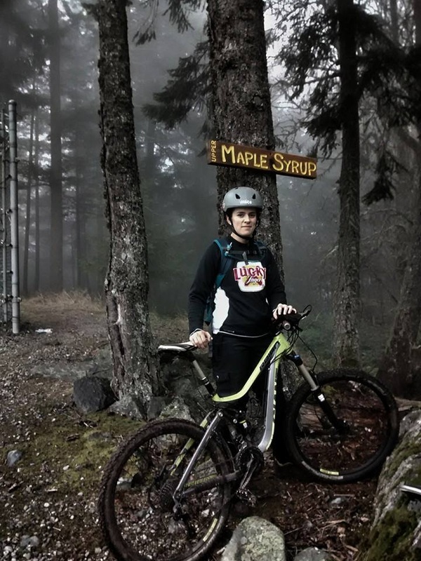 At the trail sign on the right of the building |
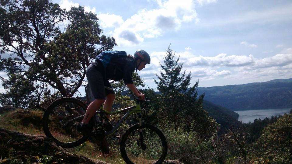
The top of the trail starts out steep over some bluffs and through the forest. The two times we were there it was a bit wet and there were a few steep hairy spots. I bailed pretty good the second time we went on a slick bluff. Regardless it was fast, fun, and kept me on my toes.
Eventually the trail becomes less steep is more fast and flowy with berms. There is a point when the trail turns from "upper maple syrup" to "lower maple syrup." There are trail signs that are easy to follow. There are also a couple cool structures on the lower section, including a nice wide uphill structure right before a hump-like wooden bridge over a creek. After this point there is some up and down to the trail.
Eventually the lower half of "maple syrup" is a bit more cross-country. Weaves through some rocks and around the forest until you get to trail junction. Here we generally take "solar coaster" back to the road and ride the road back to the gate.
I love the Maple Mountain trails because we end up spending more time on the ride down then we do on the ride up. How could anyone complaint about that? I would agree with others, if you live on Vancouver Island and mountain bike, you need to hit these trails!
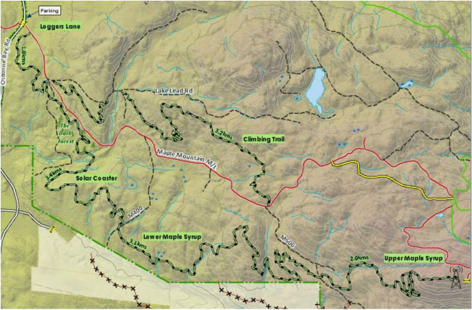
Maple Mountain Map
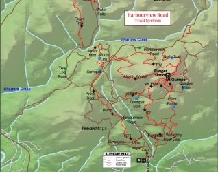 Freak Maps for Harbourview | Sooke Harbourview Another trail system we have been to a few times in the past year are the Harbourview trails in Sooke. If you are going to ride these trails I would recommend picking up a copy of "freak maps" from any of the local bike shops to avoid getting lost. To get there we drove towards Sooke on Sooke rd. We took a right on Harbourview Rd, just passed the shell gas station. At the end of Harbour View Rd there is a parking lot with bathrooms and a bike wash station. Park here and head to the gravel road on the right side of the parking lot and through the gate. Follow this road as far up as you like to hit the many trails that branch off the left and right hand side of the road. |
Quimper, FM radio, Down:
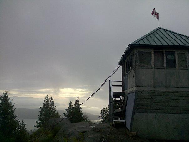
The first time we ever rode here we decided to ride all the way up Mt Quimper - Also called "whimpering up Quimper." Let me tell you I was whimpering... It is quite the ride. We stuck on the main gravel road, counting the road branches to the right in order to find the right route to the top. Eventually the counting got a bit confusing and we ended up just following tire tracks and flagging. I think it took us about 40-50mins or so to get to the right turn up the mountain. We were able to ride all of the road until this point and then it got a bit steep and rough with big loose rocks. We had to hike our bikes a fair bit for the rest of the way up. The route stays on an old skidder road and eventually turns to trail before the summit. There is a branch off to the right that heads down just before the summit. This is the trail "FM radio"- the trail we took down. We left our bikes at this junction and walked the rest of the way to the top. Eventually we made it to the beautiful summit and old fire watch cabin. It is pretty darn cool and quite sturdily built. There are amazing views of the Sooke Basin from here.
The first time we ever rode here we decided to ride all the way up Mt Quimper - Also called "whimpering up Quimper." Let me tell you I was whimpering... It is quite the ride. We stuck on the main gravel road, counting the road branches to the right in order to find the right route to the top. Eventually the counting got a bit confusing and we ended up just following tire tracks and flagging. I think it took us about 40-50mins or so to get to the right turn up the mountain. We were able to ride all of the road until this point and then it got a bit steep and rough with big loose rocks. We had to hike our bikes a fair bit for the rest of the way up. The route stays on an old skidder road and eventually turns to trail before the summit. There is a branch off to the right that heads down just before the summit. This is the trail "FM radio"- the trail we took down. We left our bikes at this junction and walked the rest of the way to the top. Eventually we made it to the beautiful summit and old fire watch cabin. It is pretty darn cool and quite sturdily built. There are amazing views of the Sooke Basin from here.
 | 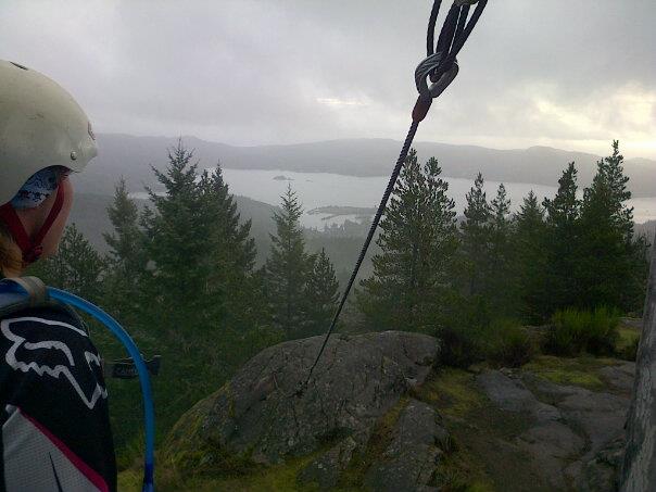 |
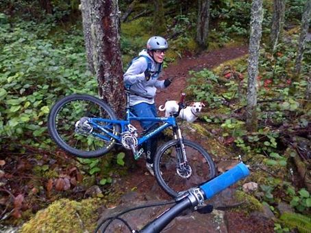
After having a snack and a bit of a break taking in the view, we headed down the mountain. We ran down to our bikes and took "FM radio." It is a pretty chill flowy trail. It goes over a few rocks and it was a bit slick, so I ha a bit of a funny mishap as you can see in the picture. I got wedged between a rock and a tree. I was having trouble getting free when Darryl came around the corner.
When we eventually emerged back onto the road we crossed the street and took a pretty standard route down including the trails "kumquat," "ankle biter," "hump," "GT1," and "GT2."
When we eventually emerged back onto the road we crossed the street and took a pretty standard route down including the trails "kumquat," "ankle biter," "hump," "GT1," and "GT2."
Kumquat, Ankle Biter, Hump, GT1, GT2:
After that first ride we did a couple smaller rides just taking the main road up to the top of "kumquat," which is off the fourth obvious road on the left. It is only about a 20min climb on the road. "Kumquat" is a nice little cross-country trail. There are a quite a few slippery roots and logs if it is wet. This trail leads back onto the main road and you have to take the first trail again on the right hand side heading down off the road to hit "ankle biter." Again this trail is cross-country, but starts to emerge out onto some more open bluffy rocks.
After a few minutes we emerged onto an old skidder road. The map here was confusing and said that we should just directly cross the road to hit "hump." However, this is not the case. We had to go right in order to find "hump." This trail is pretty similar to "ankle biter," but has a few more fun rock rolls and is more flowy.
Again, we were eventually spit back onto the main road. We took the next branch to the right again to ride "GT1," which is more fast, flowy, and bermy. There are even a few jumps to hit. After a short ride, we hit another logging road, which we crossed and rode slightly to the right to hit "GT2," which is just like "GT1" and takes you right to the parking lot. This whole ride only took about 40-50mins. Below is a video of these trails:
K2:
One of the next times we rode Harbourview we decided to ride some more on the right side of the road, but did not want to ride all the way to the summit of Quimper again. We took a right on a side road called Quimper Main off the main road. It was a bit confusing to find because there are a few fake roads that start and don't go anywhere. Eventually we joined up to the junction of "airflow" and "K2." From what I have hear these two trails are quite popular.
We took a right on "K2" and headed down the mountain. It was pretty gnarly. I am hoping to go back and try this trail when it is more dry. It is quite steep and rocky in some spots. We each had a pretty good tumble on the way down. There are also some bigger jumps that we did not attempt. When we got to the bottom we decided to ride back up the road and do our usual sequence of trails on the other side of the road back to the parking lot.
Partridge Hill
Partridge Hill is little bit confusing if you have never been with someone that knows the area. Darryl and I got a bit turned around when we went on our own. There is a "freak map" for this area, but the trails are not named and the map is a bit out of date. I eventually went with some friends that knew the area and put some flagging out for future use, most of which is all ripped down now.
Partridge is a great spot for Victorians to ride that are getting a bit sick of the same old trails at Hartland. It is a little less worn in and a bit more cross-country. Heck, if you are feeling really spry you can do what my fiancee and I did and ride them both since they are only separated by Willis Point Rd. You would just need to follow the road to the right after you pop out at the bottom of "Trillium" all the way to the bottom where it hits Willis Point Rd.
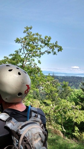 Viewpoint during the first uphill grunt | To get to Partridge Hill there are a couple options for parking. Drive west on Willis Point Rd until just before Durance Lake and there are a few parking spots off on the right side of the road and the start of a trail. This is a nice little cross-country trail I have heard called "three wise men" or on strava "wink, wink, nudge, nudge" that adds 10mins onto your ride and pops you out on the far east end of the lake. Once you get out onto the walking path take a left heading west along the lake and look for the start of a trail on your right. Another option is to park in the parking lot for Durance Lake and then ride the walking path that heads back east along the lake until you see an obvious trail to the left. Darryl and I always do the same loop for a couple reasons. First off, we have no idea where we are going so sticking to the same route makes it hard to get lost. Also, it is a solid ride, about 8-9kms and takes around 1hr15-30mins depending if you park on Willis Point or park at Durance. It has some good uphill grunts, technical bits, and downhill fun. |
| Now I know it isn't very fair... But I can't quite explain the route thoroughly since there are many turns and trail junctions... I can suggest getting a guide and laying flagging like I did. However, here is as much as I can recall: To start the climb take the main trail up as I stated above and take the first obvious right on a wide old road/trail. Take the first left on this trail and start a steep, quite relentless climb keeping left until you eventually pop out into an opening with a great view of Saanich/Sidney. I generally take a good breather here and then follow the rest of the trail up for a short while until it takes a fun plunge back down and spits you out at a creek crossing. From the creek crossing go up along the opposite side of the creek and eventually you end up on a big wide old road/trail again. Follow this south and take the first trail on your right. This is a technical uphill climb that again eventually brings you out onto a road. From here the twisting and weaving begins and things get a bit confusing. Basically, you weave around on a number of trails around the summit that pop you out at various bluffs with amazing views of the Gowland Todd and Saanich Inlet. Clear as mud? 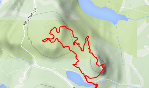 Topo GPS map of our route |  Start of the technical climb 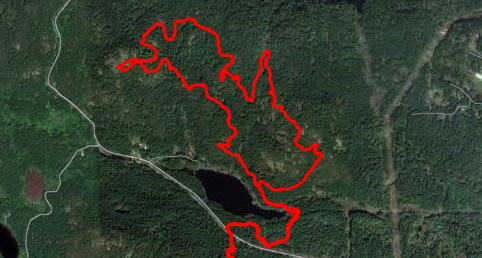 Satellite GPS route |
 |  |
Messing around at the top, Saanich Inlet in the background
Looking to the left (south east) of the viewpoint in the picture above is the start of the downhill descent back to the lake. This is my favourite part of the ride! There are a couple options: the first is to take a right at your first trail junction and ride a trail called "side winder," which adds on a few minutes, but is a great flowy downhill ride. The second is to take a left at your first trail junction called "watchdog," which is a new trail that is bermy and fast that gets you down the mountain in no time. Both eventually get on onto an old/road trail that you must take a left on and then the first right through a boggy area over a very small creek crossing. This trail is called "the urge" and gets you back to the lake. It is a little less steep then what you just rode, but is downhill, fast, flowy, and a lot of fun! And just like that -BOOM- you are back at the start...
Hornby Island
I know that Hornby Island is not technically Vancouver Island; however, you must travel from Vancouver Island to get there so I figured I would throw it in there. It is a fantastic place to ride that we have made an effort to come back to every year. We generally plan our annual trip to stay at the Tribune Bay Campsite and bike in early August. We access the trails by taking Slade Rd to the very end where there is a parking lot. Again I recommend grabbing a copy of "freak maps," which has a decent map for this area.
In previous years we have taken a long route up to the top that is pretty standard and kind of lame. We would ride from the Slade Rd parking lot left onto "colts foot" and then ride"jessie's trail" and the "summit trail" to the top. This takes a bit of time but gets you riding along the ridge at the top of the mountain taking in some nice views.
 View from Summit Trail |  |
The first year we did this we took a popular trail called "four dead aliens," which is GREAT. We then crossed "north wind" and took "yer mom," which is a bigger jump trail that has a good log skinny to start of the ride. Because of the long ride up we had done we were pretty much pooped and ready to have some beers so we back-tracked to get to "no horses" and then called it a day.
Skinny on "yer mom"
The next year we went with an experienced pal who showed us a much better way to utilize the trails and make smaller loops that you can ride all day. Again we took Slade Rd and left on "colts foot," however, we then took a right on "north wind," which takes you up the mountain to the north where all the good trails are. This totally avoids the big loop to the south.
One of the loops we took we to ride up "north wind" to "cold deck" and turn lefts on "Mr Toads wild ride," to "tadpole," "chris and brads," and "no horses." "No horses" is a MUST if you are riding Hornby. It is a cool half pipe-like trail down a small little riven. From here we took a left on "washing machine," which is a little climb that gets you back onto "north wind" where you can ride up and start again.
Another loop we did was to ride up to "cold deck" all the way until you hit the "cliff trail climb." This has some great views and is a good rest spot for lunch or a beer. We headed slightly up the climb until we could take a left on "purgatory" to "bitchin camero" and "slick rock," which is a slightly more technical, fast downhill rip. I really enjoyed some of the little launches on this route.
All in all, if you are looking for a great trip in the summer, Hornby is the spot. The beaches are beautiful, the camping is fun, and the biking is amazing. Here is a link to a good trail map for Hornby that lists the distance/elevation for each trail:
http://www.hornbyisland.com/activities/mountain-biking/
Below is a video summary of our Hornby trip and some other island fun:
 RSS Feed
