Don't let the title scare you, Mount Manuel Quimper is a great day hike for those looking for a great view of Sooke, the Sooke Hills, the Westshore, Olympic Mountains, and Victoria. It also offers the chance to check out an interesting old fire watch station at the summit.
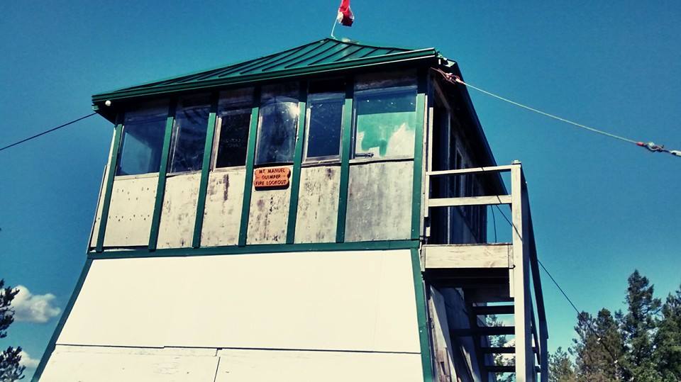
Mount Manuel Quimper was originally named Mount Shepherd after a crew member on Captain Kellett's Boat in 1846 while he was surveying the Sooke Basin. Later the mountain had its name changed to Manuel Quimper after a Spanish explorer who landed in the Sooke Harbour back in 1790. The original fire watch station was built in the 1920's and had a man posted every summer to watch for fires. He would have supplies brought up to him throughout the months that he was stationed there. Seems like a pretty decent job to me!
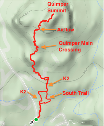
I have mentioned Mount Manuel Quimper previously in my blog because it is also a great place to mountain bike. It is accessed by taking Sooke Rd north towards Sooke and turning right on Harbourview Rd. As I have mentioned previously there is a great parking area at the very end of the road complete with bathrooms and a bike wash station. The route we took to the summit and back took us around 2.5-3hrs and was 8.6kms. The summit is 546m in elevation. Below I have posted a picture of a map of the area. This can be found at opencyclemap.org. I highly suggest getting an app like "Canada Maps" that uses opencycle and a GPS to show you exactly where you are on the trails. Makes it easier to navigate.
Mount Manuel Quimper was originally named Mount Shepherd after a crew member on Captain Kellett's Boat in 1846 while he was surveying the Sooke Basin. Later the mountain had its name changed to Manuel Quimper after a Spanish explorer who landed in the Sooke Harbour back in 1790. The original fire watch station was built in the 1920's and had a man posted every summer to watch for fires. He would have supplies brought up to him throughout the months that he was stationed there. Seems like a pretty decent job to me!
I have mentioned Mount Manuel Quimper previously in my blog because it is also a great place to mountain bike. It is accessed by taking Sooke Rd north towards Sooke and turning right on Harbourview Rd. As I have mentioned previously there is a great parking area at the very end of the road complete with bathrooms and a bike wash station. The route we took to the summit and back took us around 2.5-3hrs and was 8.6kms. The summit is 546m in elevation. Below I have posted a picture of a map of the area. This can be found at opencyclemap.org. I highly suggest getting an app like "Canada Maps" that uses opencycle and a GPS to show you exactly where you are on the trails. Makes it easier to navigate.
The route that we took included walking up a couple popular mountain bike trails. I know that many have conflicting ideas about this, but in my opinion since mountain bikers built and maintain the trails like "K2" and "Airflow" that means that they have the right of way. Always be on your toes and listening for bikers so that you can quickly get out of the way. The reason I chose to take us up this route was because it was quite direct and had many great views even before the summit. Always be courteous and respect the jumps and structures on the trail. Try not to step on any of the dirt mounds built up, they are meant for riding not walking.
We started off by parking at the end of Harbourview Rd in the parking area and then took the gravel road that almost immediately splits to the right. We then took the first trail on the left, which is the start of K2. It is also possible to keep going and take the trail that emerges at the end of the road called "South Trail," which is what we took on the way down. There are a number of branches to choose from after a short while on K2, which is where I found my phone app helpful. Also, sticking to the most well-beaten trail also works. You should cross an old road called "Lower Tier Trail" and if there is not a trail directly across the road take a left and you should see one emerge on your right. This is again K2.
We started off by parking at the end of Harbourview Rd in the parking area and then took the gravel road that almost immediately splits to the right. We then took the first trail on the left, which is the start of K2. It is also possible to keep going and take the trail that emerges at the end of the road called "South Trail," which is what we took on the way down. There are a number of branches to choose from after a short while on K2, which is where I found my phone app helpful. Also, sticking to the most well-beaten trail also works. You should cross an old road called "Lower Tier Trail" and if there is not a trail directly across the road take a left and you should see one emerge on your right. This is again K2.
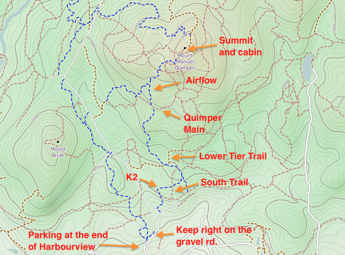
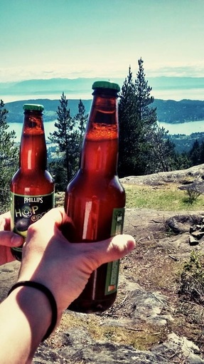
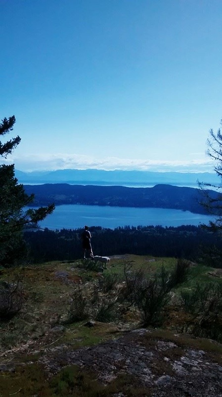 | 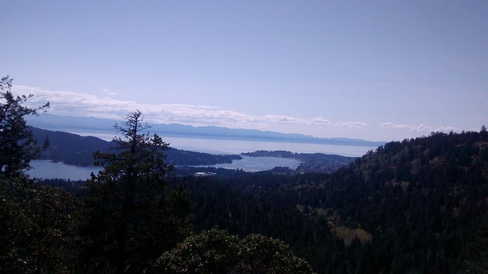 After finding K2 it is smooth sailing right up to the next old road crossing called "Quimper Main". K2 weaves through the beautiful forest and steadily climbs up small rock faces. Eventually you pop out onto a few good spots with views of the Sooke Basin and East Sooke Park. Once you hit Quimper Main take a left for a minute and you will see the K2 connector to "Airflow" start on the right. Again this is smooth sailing to the top. You will see a few other trail crossings, but just keep heading up. When my friend Lauren and I reached the top we were greeted with phenomenal panoramic views of the area. The day was warm without a cloud in the sky. We headed in for a quick peek inside the old fire watch station, which is actually not in bad shape. Inside we found two philips beers sitting on a bench calling our names. We then grabbed the beer and cracked them open to celebrate a fantastic hike. |
 |   |
 RSS Feed
