
Cayoosh summit is easily viewed when driving the Duffey from Lillooet to Pemberton. It is a neat mountain with many sub-summits and reddish rock strewn throughout. It sits at 2561m and is accessed by from a parking lot just in between Joffre Lakes and the Marriot Basin. Darryl and I did this summit as a day trip and summer ender bucket list item.
We set off at 0600 from Lillooet and were hiking up the access road by 0700. It was the start of a beauty day and we had company arriving at our house so we were in a bit of a time crunch. The road at the start of this trip was easily walkable and I wished I had brought my truck to save us some time. The road walk was however very short, only around 3k. There is a high road fork we took the last time we attempted this summit. When we passed by it on this day it looked very grown over so we decided to just pick our way up from the end of the road with the cabin.
It didn’t take us long to reach the end of the road and off we headed into the bush. It looked slightly promising at first with a bit of a route, but quickly turned into a bush bash through huckleberries, around alders, and over many logs. We headed north at first and then trended west/left to gain an avalanche chute filled with large boulders. We were already sweaty and covered in debris by the time we reached this point. I was unhappy with the time consuming bushwhack.
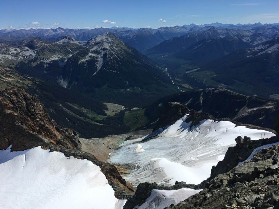
We hopped our way along boulders and eventually found some cairns and flags that signaled where we should cross into the forest and into the upper basin. We followed a faint trail through the woods here and ended up on more boulders on the other side... I was noticing a trend… We hopped along until we reached a small lake and followed the basin at an easy grade upward. Here we lost any sign of a trail, cairns, or flags.
Soon we hit a steeper grade of intermittent scree, heather, and small trees. We worked our way up trending to the north, or right side of the basin. We eventually got below the Cayoosh summit block and took a small ramp up to the right, which varied slightly from the directions in the Matt Gunn Scrambles book. His directions had you sticking straight to the end of the basin and then heading right once you gained higher ground. I felt my way saved us a bit of distance.
We dawned our helmets at the base of the summit block and closely read the book. The description was a bit vague and we had a bit of trouble picking our way up. We stuck to closely to the ridge at first, but eventually weaved our way back right/east and gained the proper gully. We finally noticed some obvious boot prints signaling that others had been there.
We climbed up the loose rock and shale, going very carefully and trying not to kick rocks at each other. It was quite nasty actually. Things got progressively sleeper until I was getting a bit concerned we were off track. I made one fairly exposed scramble move and popped back out on the ridge just below the sub-summit on safer ground. Hooray!
We set off at 0600 from Lillooet and were hiking up the access road by 0700. It was the start of a beauty day and we had company arriving at our house so we were in a bit of a time crunch. The road at the start of this trip was easily walkable and I wished I had brought my truck to save us some time. The road walk was however very short, only around 3k. There is a high road fork we took the last time we attempted this summit. When we passed by it on this day it looked very grown over so we decided to just pick our way up from the end of the road with the cabin.
It didn’t take us long to reach the end of the road and off we headed into the bush. It looked slightly promising at first with a bit of a route, but quickly turned into a bush bash through huckleberries, around alders, and over many logs. We headed north at first and then trended west/left to gain an avalanche chute filled with large boulders. We were already sweaty and covered in debris by the time we reached this point. I was unhappy with the time consuming bushwhack.
We hopped our way along boulders and eventually found some cairns and flags that signaled where we should cross into the forest and into the upper basin. We followed a faint trail through the woods here and ended up on more boulders on the other side... I was noticing a trend… We hopped along until we reached a small lake and followed the basin at an easy grade upward. Here we lost any sign of a trail, cairns, or flags.
Soon we hit a steeper grade of intermittent scree, heather, and small trees. We worked our way up trending to the north, or right side of the basin. We eventually got below the Cayoosh summit block and took a small ramp up to the right, which varied slightly from the directions in the Matt Gunn Scrambles book. His directions had you sticking straight to the end of the basin and then heading right once you gained higher ground. I felt my way saved us a bit of distance.
We dawned our helmets at the base of the summit block and closely read the book. The description was a bit vague and we had a bit of trouble picking our way up. We stuck to closely to the ridge at first, but eventually weaved our way back right/east and gained the proper gully. We finally noticed some obvious boot prints signaling that others had been there.
We climbed up the loose rock and shale, going very carefully and trying not to kick rocks at each other. It was quite nasty actually. Things got progressively sleeper until I was getting a bit concerned we were off track. I made one fairly exposed scramble move and popped back out on the ridge just below the sub-summit on safer ground. Hooray!
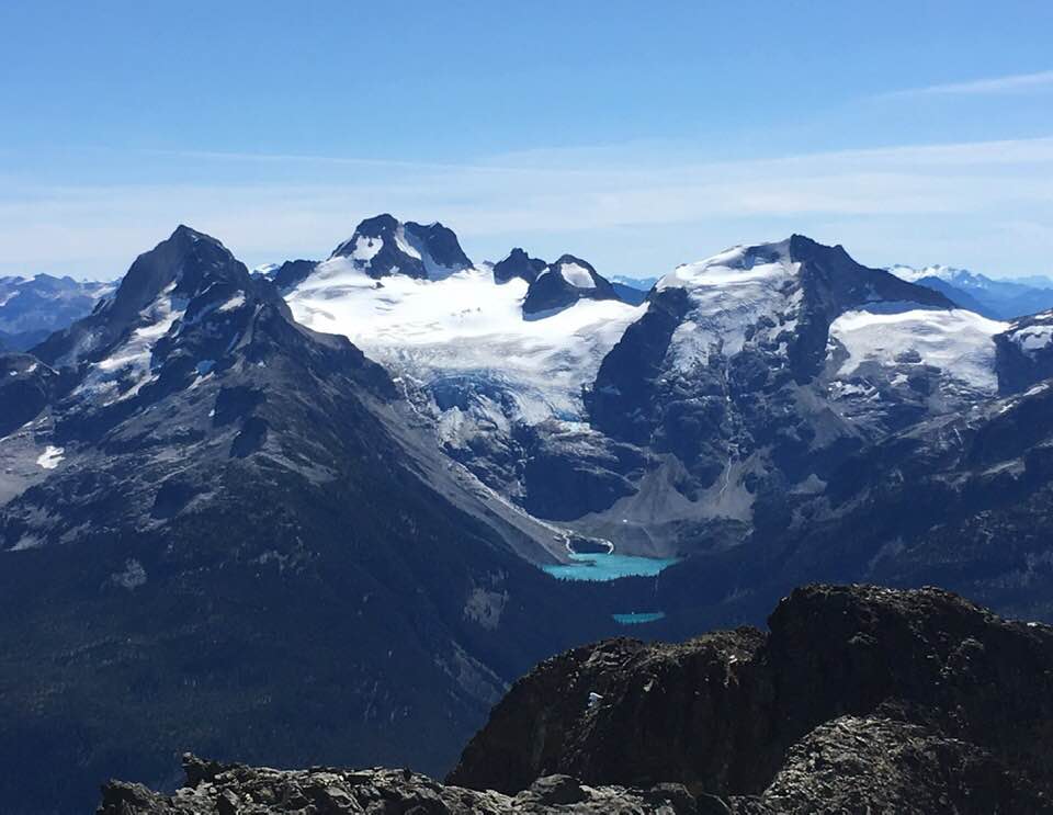
Joffre Lakes area. Joffre Peak far left, Matier in the middle, Slalok to the right.
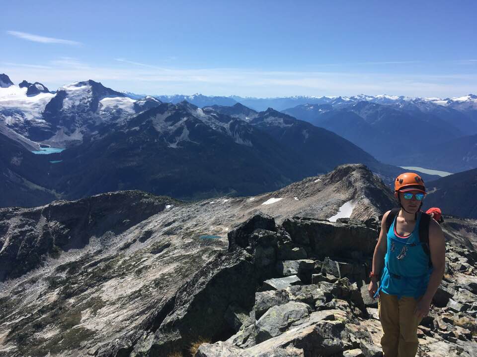 |  |
Mount Marriot far left
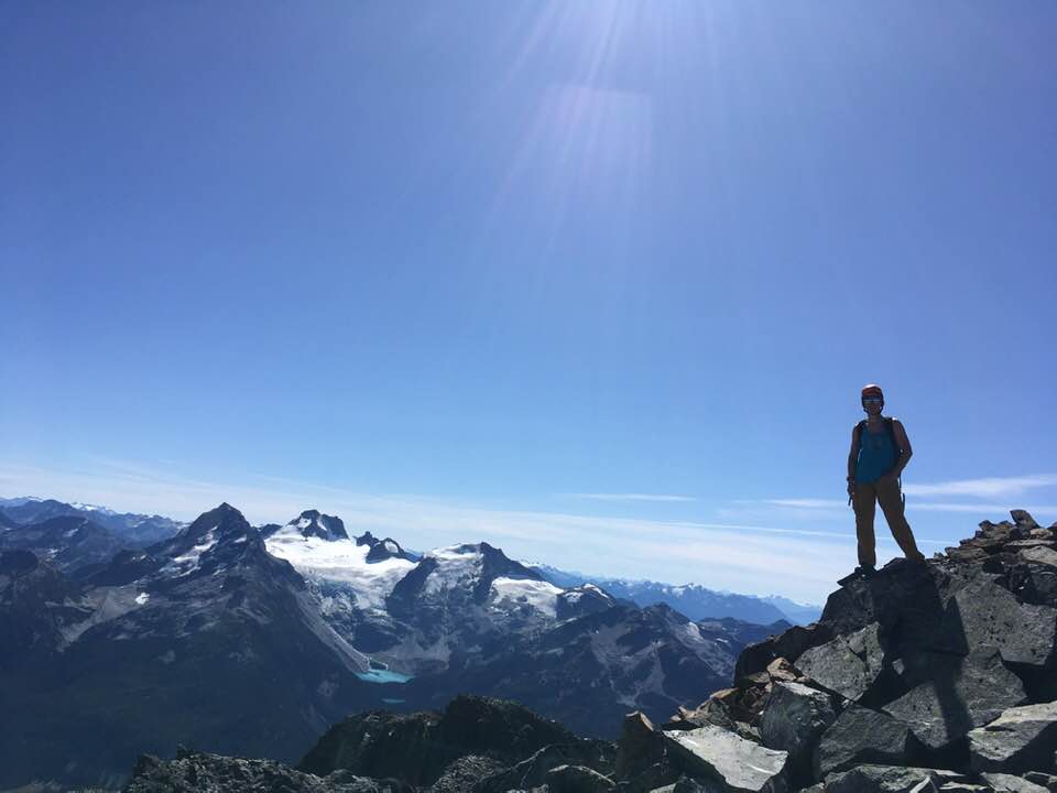
Mount Rohr and Rohr lake
From here the ridge scramble to the sub-summit and on to the true summit was great. The rock quality was better and the views were outstanding. We made it to the summit in about 5 hours total from the car. We sat and took in some sunrays and ate some snacks. The view of Joffre was very neat. We could also see back towards the Marriot Basin and where I have skied a couple times. It was wonderful.
We carried on back down the way we came after not too long. We worked our way down the ridge and slowly down the gully system to the base of the summit block. The rock was again garbage and we had to go slowly. From there we walked down the way we came through the basin and back to the final avalanche chute. Once there we decided to try and find our way back to the upper road branch we had passed on the way up. We had done it the year previous so we didn’t think it could be THAT overgrown… We picked our way over without looking all that hard for signs of a trail and ended up in yet another epic bush bash. This time we had no idea if we were above or below any road. I saw a small stand of alder and I should have made us head for that, since alder likes to grow on road… Instead I trusted the GPS, which said that the road was above us. We hiked up all the way to a stand of old growth timber and realized we had come up too far. Back down the hill we fought, through the thick bush and down to the stand of alder I had been eyeing up. Sure enough there was the road. Brutally grown over, but still there. It felt as though we were the only ones to walk there this year. I guess this isn’t a very popular hike any more.
We clambered down through the alder with haste. We had visitors coming! I had to basically hold my hands up in front of my face and walk blindly. We popped back out on the main road and finally walked with minimal resistance back down to the car. We arrived at the car after 17k and 9h15mins round trip. This was certainly not my favorite scramble of the summer due to poor rock quality and a mediocre approach… but fun nonetheless!
 RSS Feed
